We Love Camelford
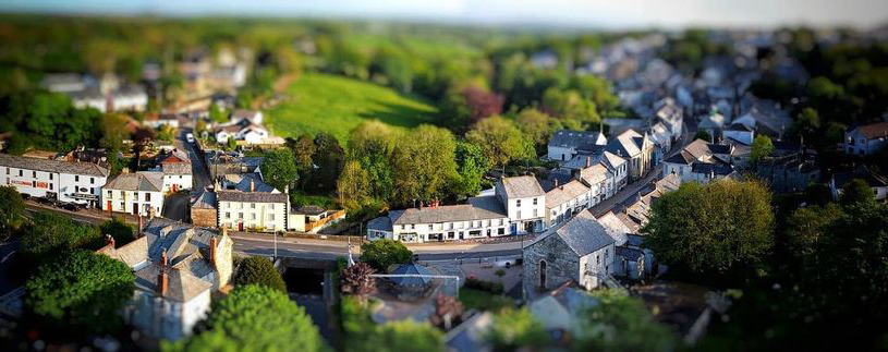
Camelford is a pretty market town, ideally placed to explore the peaceful moors and the beautiful rugged coastline. It is easily accessible from the A30 (follow North Cornwall, Camelford sign) and straddles the A39. Within 10 minutes, you can be walking along the golden beach of Trebarwith Strand (our nearest beach and dog-friendly all year round) or exploring the Neolithic settlement sites on Bodmin Moor. The town has an array of shops and eateries, free public toilets at either end of town and free car parking for 2 hrs.
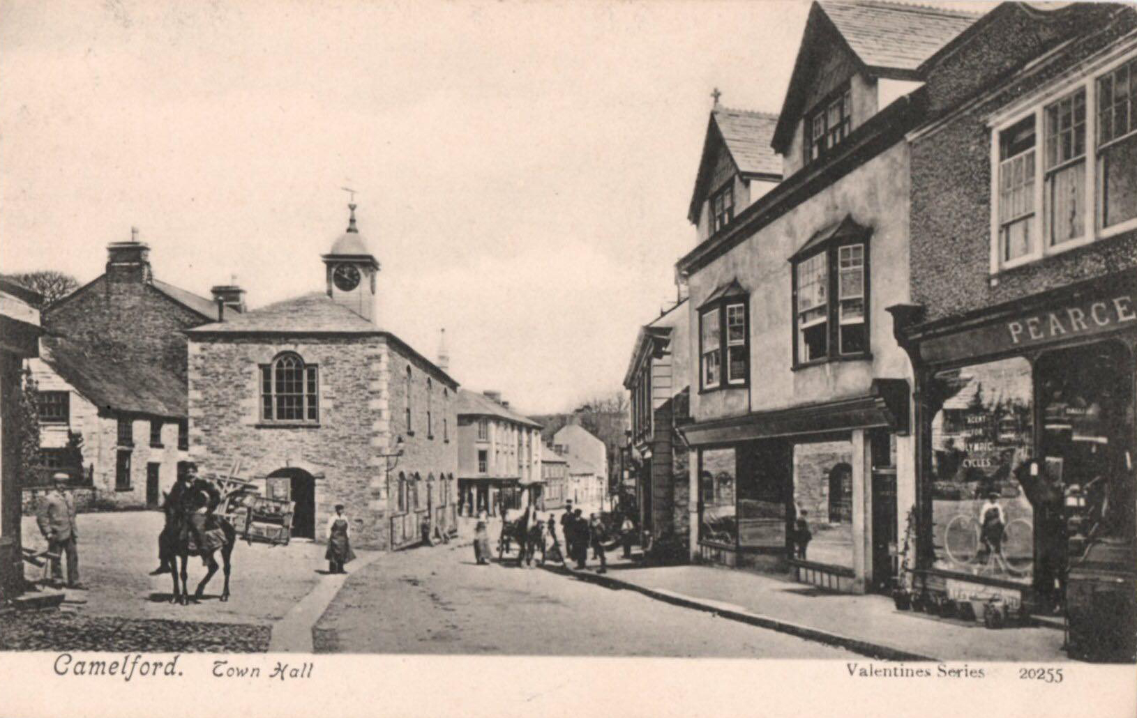
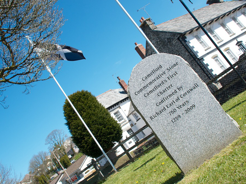
The ancient town of Camelford was an old medieval trading route. It became an important commercial centre when a royal charter was granted in 1259 by Richard Earl of Cornwall. This marked the creation of the present Borough. For more historical information, visit Camelford History Archive Trust (CHAT) CHAT.
- Walkers paradise
- Family-friendly
- All year round community
- Historic Cornwall
local Area
There’s plenty to explore, from the legend of King Arthur at Tintagel or the smuggler’s coves and surfing beaches. Bodmin Moor is the perfect place to stargaze, we are ideally located to sample the best North Cornwall has to offer.
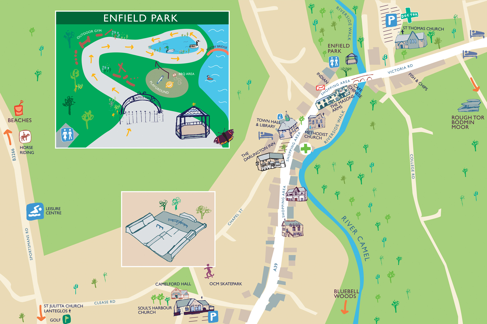
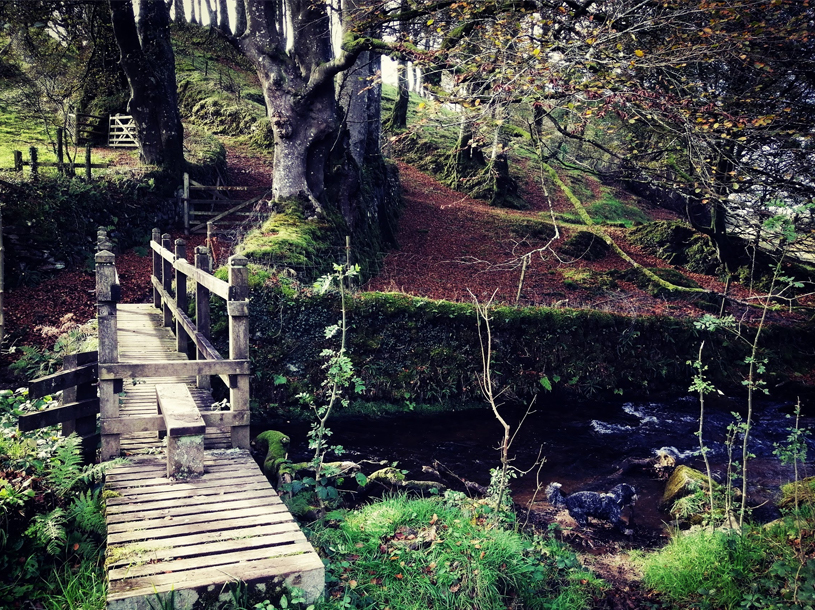
Walks - Camelford Town Trail and Enfield Park
We have some stunning walks right on our doorstep! This is the Green Route, a leisurely walk around the town centre and park should take about an hour but we hope you will spend a little longer and make full use of the shops and facilities we have to offer. The park has a solid surface circular path that is wheelchair friendly. There are free toilets and a water fountain at the entrance to the park. Download our pdf for the route.
“... a snaking street with fine historic buildings backed by green fields with mature trees along their hedges.” John Betjeman

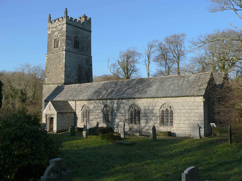
Walks - The Three Churches
The Red Route is a triangular walk linking the three churches, Camelford, Advent and Lanteglos. A wonderful way to take in some Cornish history and see our stunning countryside. Download our helpful pdf guide for more information.
Walks - Watermill
The White Route takes in dramatic countryside views and follows the river Camel.
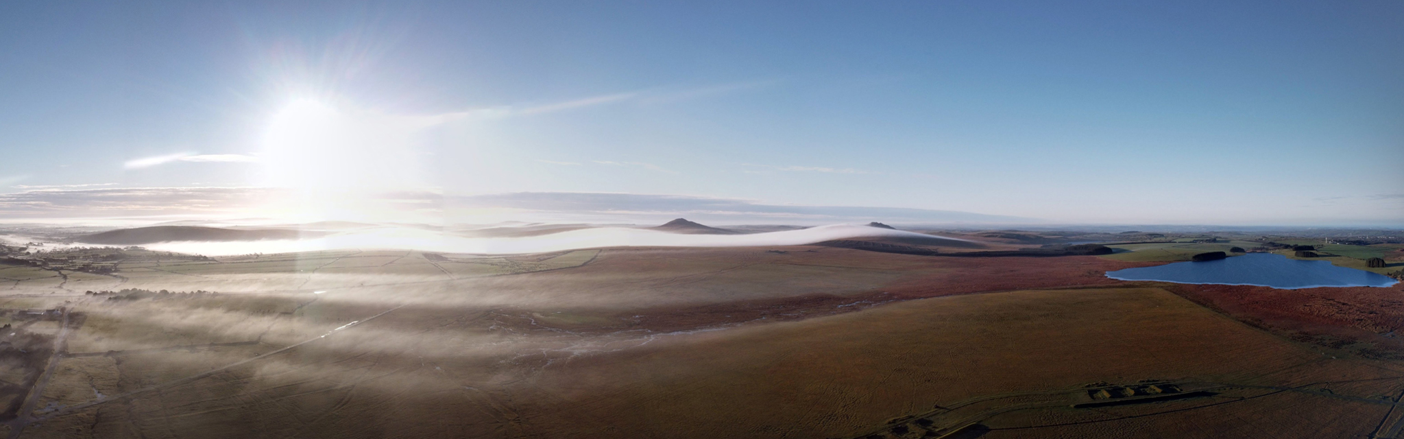
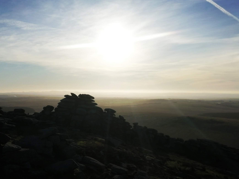
Roughtor
Rough Tor is approximately one mile northwest of Brown Willy, Cornwall's highest point, on Bodmin Moor. Its summit is 1313 ft (400m) above mean sea level, making it the second-highest point in Cornwall. Both hills are near the town of Camelford. Some local firms include the tor in their tours. The De Lank River rises nearby and flows between the two hills. Rough Tor and Little Rough Tor are twin summits of a prominent ridge of granite, though there are actually three tors at the site: Showery Tor, Little Rough Tor, and Rough Tor.
Hikes to the summit and to neighbouring Brown Willy are popular, though the walk may be strenuous; a road provides easy access to a car park, which is about a mile and a half from the summit.
The Rough Tor enclosure is located in an area containing numerous upstanding monuments and other Bronze Age sites, such as the Fernacre stone circle, which is only 200 metres from the site. Stannon stone circle is also located nearby, and there are numerous cairns and burial monuments in the vicinity.
On the southern slopes of Rough Tor, there are the remains of a large number of stone hut circles, set around three or four enclosures that may have held stock. There are also the remains of a large field system, which is partially overlain with a medieval field system. The purpose of this field system has been debated, with historians disagreeing as to whether the fields were used for cereals or for stock.
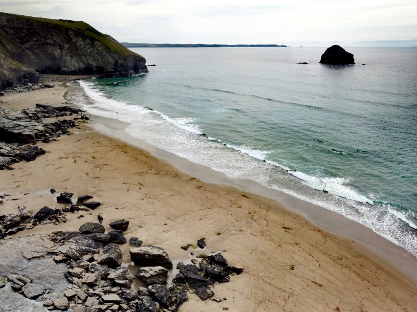
Trebarwith Strand
Trebarwith Strand is a popular family beach known for its fine golden sands, located on the North Cornwall coast - between the ever-popular villages of Port Isaac and Tintagel. Located at the very bottom of a deep valley, with many attractive views along the Heritage Coastline - with Gull Rock, lying just of the beach providing an interesting focal point to the views.
The route to Trebarwith Strand is via a narrow single track lane, running from the B3263, through a narrow steep-sided valley down to the small hamlet of Trebarwith Strand. At the end of the lane, Trebarwith, has car parking, a cafe, shop, toilets and a pub serving food. The Strand café is a popular stop at the Strand - selling a range of freshly prepared food and homemade cakes. There is a small surf shop that provides the standard "Bucket and Spade" type holiday requirements as well as offering wet suit and bodyboard hire. Trebarwith Strand Surf Shop began life in the 1920s as "Keats surf shop"- hiring out surfboards.
Trebarwith Strand Beach is easily accessible from the parking area via a short walk down the hill. The beach has a reasonably large area of sand and rocks at low tide - and is a firm favourite with locals and holidaymakers, often arriving in campers. At high water, the sands are completely covered by the incoming tide. But as the tide recedes, a superb all-round beach is revealed, that offers good bathing and surfing with plenty of rock pools and small alcoves to explore along the cliff edge.
Lying in the bay, just off of the beach, is Gull Rock - an imposing cliff stack, that provides a home to many local sea birds. The picturesque setting with Gull Rock lying just over 600m from the shore, makes the area popular as a TV and Movie location.
The beach at Trebarwith Strand is a collection of smaller beaches and coves, which join up at low tide to create a mile-long strip of golden sand. The beach has distinct sections, each with its own character:
The western edges of the beach, below the cliff edge car park of the Port William Inn, is mainly a rocky platform, with some sand at the lowest point of the tide. This stretch of beach is not safe for family use, due to the rocks and the strong currents, but is popular with local surfers.
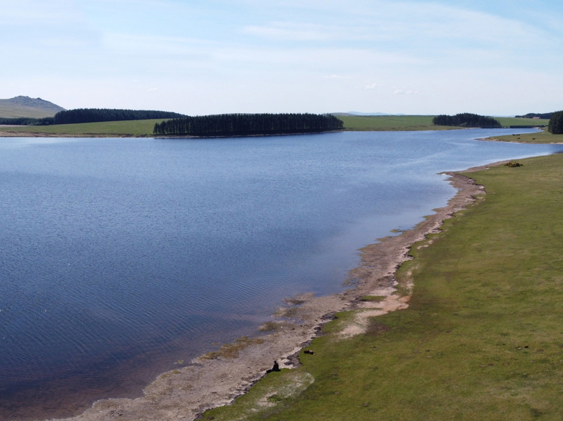
Crowdy Reservoir
Crowdy Reservoir is situated within a Site of Special Scientific Interest (SSSI) on the northern tip of Bodmin Moor. This is a quiet and peaceful spot, boasting lovely moorland views and a soundtrack of birdsong. The area is home to an incredible range of wildlife, with spectacular starling murmurations occurring at certain times of the year and a range of wildfowl.
Free wilderness brown trout fishing is available for wild fish from the bank. This fishery is not stocked but it has a good natural head of brownies with some fish previously recorded to 4lbs.
Anglers must have a valid Environment Agency Rod Licence (non-migratory).
Permitted angling methods at this reservoir include spinning, fly or bait. ‘Catch and release’ is preferred using barbless hooks, otherwise up to 4 fish over 7″ may be taken in a day.
Our History
Camelford is an ancient town that is about six miles inland from the North Coast and lies on the edge of Bodmin Moor. Today the A39, the Atlantic Highway runs through the town.
The word Camelford is believed to be derived from ‘cam’ meaning ‘crooked stream’ in Celtic, and ‘alan’ meaning ‘beautiful’ and ‘ford’.
There has been a bridge in the town over the River Camel which winds its way through the town, since 1521. The original hump-backed bridge was replaced in 1958 to prevent flooding which had plagued the town for centuries.
The town was situated on a medieval trading route and was an important centre of commerce when Richard Earl of Cornwall created the present borough in 1258. This was confirmed by the Royal Charter by Henry 111 in 1259.
The effects of the Charter remain in the town with the marketplace and market House at the Centre which later became the Town Hall. The basis of the town’s economy was agricultural and the market was comprised of livestock and produce sales.
At the end of the Civil War King Charles 11 needed to exercise close control over parliament with a compliant House of Commons. He did this by granting new Charters to a number of towns of which Camelford was one.
Under the Charter of 1669, the Corporation acquired the title of Mayor and Burgesses. The burgesses were given the rights to customs, tolls, profits and any other income from the fairs and markets that the Charter allowed the Burgesses to hold in the town.
As a result, the town’s inns and businesses thrived and the patronage of the MPs brought a lot of money into the town which is reflected in the many Grade 2 buildings to be found in the centre of the town. The symbol of the camel, as used on the Town Hall weather vane paid for by the Duke of Bedford is used often in connection with Camelford although the name has nothing to do with camels.
Some believe that King Arthur and his knights form part of North Cornwall history and that Camelford was once the famed ‘Camelot’. The truth has been lost over time as is the name of a real warrior king who died in a battle outside Camelford at Slaughter Bridge.
Whatever the true story of Slaughter Bridge, come and enjoy our beautiful surroundings for touring, walking, fishing, swimming and surfing.
Our town is steeped in history and legend which is the reason that there is a great sense of community and place in Camelford.
For more information on the history of Camelford, see Camelford History & Archive Trust (CHAT)